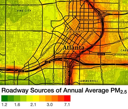
Have you ever wondered about the air quality at your child’s school or favorite park? The Atlanta Regional Commission (ARC) has a new tool that can help citizens evaluate how much fine particulate matter from transportation sources is in their communities’ air. The Atlanta Roadside Emissions Exposure Study (AREES) has produced a color-coded interactive map that highlights hot spots of locally elevated air pollution levels. The map also shows the locations of schools and hospitals.
ARC planner David D’Onofrio visited a recent M&O Leadership Board meeting to discuss the AREES study. David explained that regional air quality monitors don’t cover everywhere equally and being in attainment does not always mean air quality is not a problem, especially to those who are sensitive to air pollution.
The Environmental Protection Division (EPD) of the Georgia Department of Natural Resources ensures that the state monitors air quality as required by the Clean Air Act. The EPD currently collects air quality data from 42 sites throughout the state, but many metro Atlanta counties have only one monitoring site. AREES helps fill in some of the gaps by showing pollution levels on a neighborhood scale.
AREES can be used by decision makers when considering where to locate sensitive facilities like playgrounds, trails, parks, and other places where the most vulnerable to air pollution spend more time outside. The study confirms that air quality is generally worse in and around highly congested roads and freeways.
Mothers & Others for Clean Air is excited to announce that David D’Onofrio has joined our Partnership Council. Partnership Council members provide leadership and serves as an important resource for technical information. David’s expertise as an air quality and climate change transportation professional will be a significant asset to M&O.